Photo by SFMTA Photography Department
Introduction
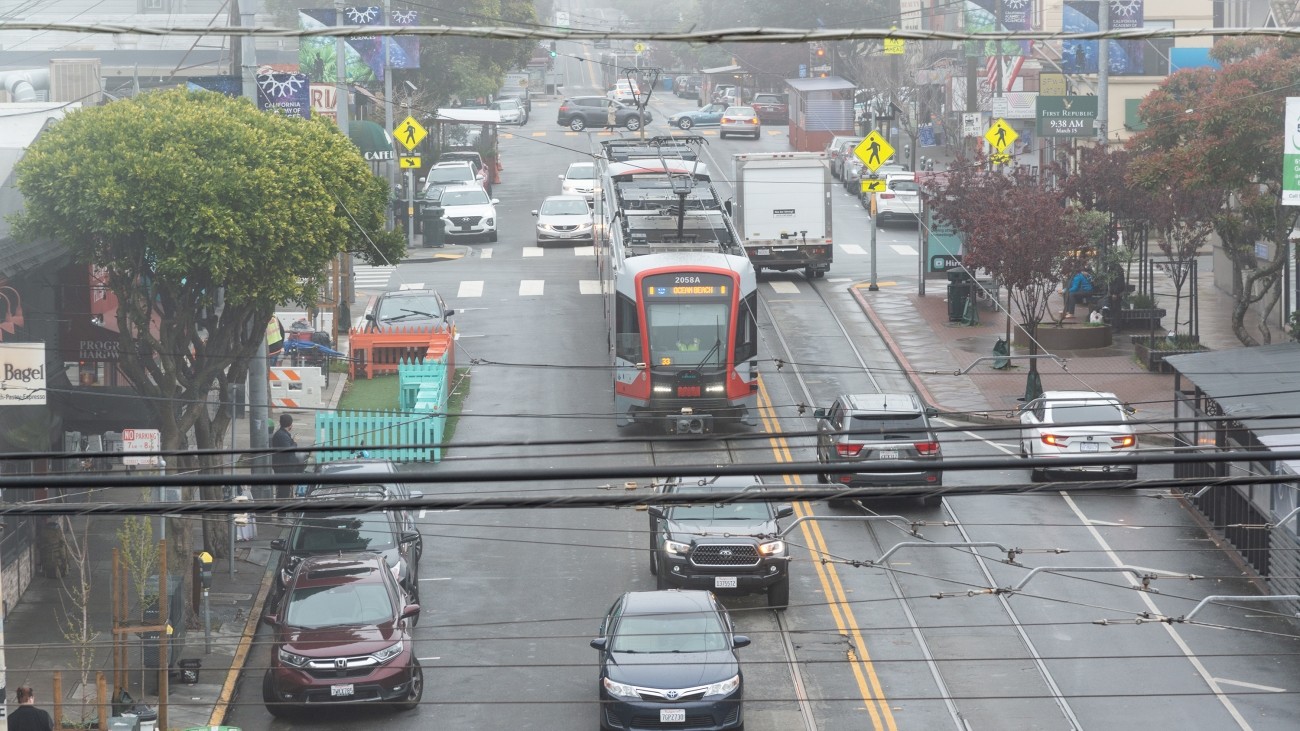
The Inner Sunset Transportation Study will identify ways to improve safety and access within the commercial core of the neighborhood, so residents and visitors can enjoy its many amenities.
The recommendations will fall into three types:
- Quicker-to-implement, lower cost safety or access improvements such as added bike parking.
- Conceptual designs for new project improvements requiring more resources to develop. This could include transit priority treatments, new signal timing, or signage.
- One or two bold concepts with community interest and potential to significantly improve on community goals, including potential for significant circulation changes and/or vehicle restrictions on commercial corridors (e.g., turn restrictions and/or “transit mall” treatments on Irving Street). These changes would require further conceptual design, evaluation, and outreach following this study.
Community engagement will take place during three points in the study process and will include in person meetings, a community activity, surveys as well as Chinese language translation.
We plan to publish outreach findings in Spring 2025.
Transportation Study Goals
The study team conducted on-site observations and analysis of transit and vehicle circulation, crash data, walking and rolling conditions, and parking and loading conditions. We have identified the following four draft project goals:
- Prioritize safety for vulnerable road users (defined as everyone traveling outside of a car).
- Improve transit reliability by minimizing transit delays and improving travel time for buses and rail in the study area.
- Enhance access to key destinations
- Sustain economic vitality
For a more detailed description of goals, learn about the project background here.
Project/Study Partners
This project is led by the Transportation Authority, in coordination with San Francisco Municipal Transportation Agency.
The Transportation Authority’s Neighborhood Program is intended to strengthen project pipelines and advance the delivery of community supported neighborhood-scale projects, especially in Equity Priority Communities and other neighborhoods with high unmet need.
Timeline and Status
-
Summer 2024
Study Area Goals and Needs
-
Fall 2024
First Round of Community Outreach
-
Winter 2025
Concept Development and Analysis
-
Spring 2025
Second Round of Community Outreach
-
Summer 2025
Recommendations and Final Report
Cost and Funding
This project was funded by the Transportation Authority’s Neighborhood Program at the request of District 7 Supervisor and Transportation Authority Board Member Myrna Melgar.
Resources
Prop L Transportation Sales Tax Funding Request (PDF)
Contact
InnerSunset@sfcta.org
Description of Transportation Study Draft Goals
From on-site observations and analysis of transit and vehicle circulation, crash data, walking and rolling conditions, and parking and loading conditions, four draft project goals have been identified:
-
Prioritize safety for vulnerable road users (defined as everyone traveling outside of a car).Issues: Lincoln is on the HIN, pedestrian and cyclist crashes concentrated in the study area
-
Improve transit reliability by minimizing transit delays and improving travel time for bus and rail in the study areaIssues: Transit stuck in vehicle queues & blocked by double parking
-
Enhance access to key destinationsIssues: Limited and high-stress bike options, long vehicle queues
-
Sustain economic vitalityIssues: Circulation issues impacting access to goods, services, deliveries
The study area and nearby streets have seen a number of changes in the last five years with a focus on improvements to prioritize people walking and rolling as well as transit safety and reliability.
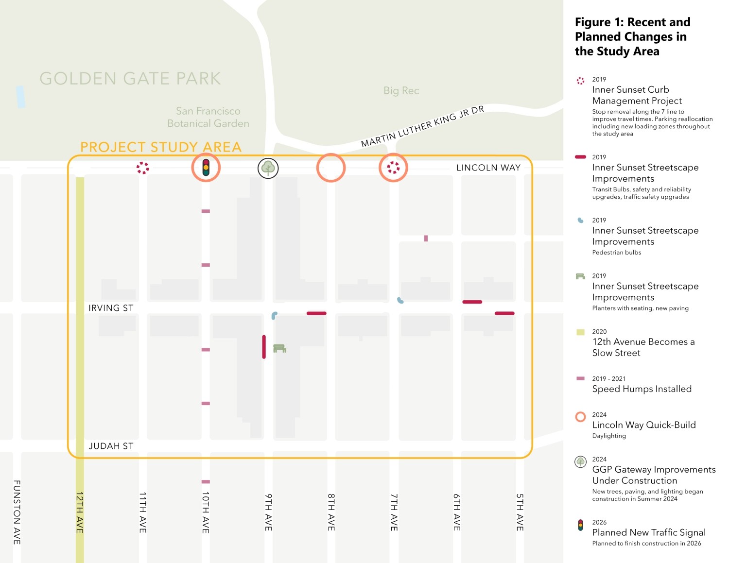
The image below summarizes the transportation projects that have been implemented in the study area in the past five years.

Recent and Planned Changes
2019
Inner Sunset Streetscape Improvements: A multi-agency collaboration improved service and aesthetics along the N Judah line, including Muni Forward transit bulbs, traffic safety updates, road repaving, and utility upgrades.
2019
Inner Sunset Curb Management Project: From 5th to 12th avenues between Lincoln Way and Judah Street, SFMTA reviewed and updated the allocation of curb space, expanding and optimizing the location of passenger and commercial loading.
2019 – 2021
New speed humps were approved and installed as part of neighborhood traffic calming programs.
2020
The SFMTA Slow Streets Program established 12th Avenue as a slow street, prioritized for active transportation during the COVID-19 pandemic. SFMTA also closed JFK Drive in Golden Gate Park to vehicle traffic to provide more space for recreation and active transportation.
2021 – 2022
Golden Gate Park Access and Safety Program: City agencies hosted a working group and community engagement to understand the level of support for car-free streets within the park. Of 9,000 survey respondents, 70% favored the car-free program. An accompanying Golden Gate Park Traffic Study showed that from 2019 and 2021, traffic volume decreased on major nearby streets while travel times for people driving did not change substantially. In 2022, San Francisco voters approved the permanent closure of JFK Drive to cars.
2024
Lincoln Way Quick-Build Project: SFMTA began construction to implement daylighting on 7th, 8th, and 10th avenues
2024
Golden Gate Park Gateway Improvements: San Francisco Recreation & Parks completed construction to redesign amenities for people walking on the northern side of the intersection at 9th Avenue and Lincoln Way. The project will include upgraded landscaping, new signage and wayfinding, new lighting for people walking and upgraded signal poles.
2024 – 2025 (In Progress)
SFMTA is working on the citywide Biking and Rolling Plan which will create a new plan for active mobility. This study will coordinate and integrate with that effort.
2026 (Planned)
New Traffic Signal: SFMTA plans to construct a new traffic signal at Lincoln Way and 10th Avenue.
Public Engagement
The Transportation Authority is working with District 7 residents, community organizations and the SFMTA.
Online survey (closed December 20).
In-Person Public Meeting with District 7 Supervisor Myrna Melgar
Public Meeting Presentation (PDF)
Community members had the opportunity to learn more, ask questions, and tell us what improvements they would like to see in the commercial core of the neighborhood.
Date: Monday, November 18
Time: 6:00 to 7:30 p.m.
Location: San Francisco County Fair Building, 1199 9th Avenue
